Ophel - THe Location of King Solomon's Temple

  • Welcome to Christian Forums, a Christian Forum that recognizes that all Christians are a work in progress.

    You will need to register to be able to join in fellowship with Christians all over the world.

    We hope to see you as a part of our community soon and God Bless!

Eulalio Eguia

New Member
Sep 3, 2015
8
0
0
It is known that the Red Heifer altar is located at the "top" of the Mount of Olives, and is due East of the Temple.

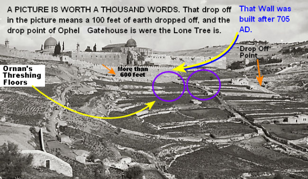
I believe the Red Heifer altar was built on a threshing floor in the Mount of Olives, similar to the Temple of Solomon which was built on the threshing floor of Araunah.

The sedimentary rock area of the Mount of Olives is an ideal place for threshing floors. So I looked for the highest elevation in this area of the Mount of Olives to locate where I believe the Red Heifer altar was built.

This is how I determined that Ophel (which is due West of the Red Heifer altar) is the location of King Solomon's Temple.

altur4.jpg


templeorig4.jpg


To know more, please watch the following video:
https://www.youtube.com/watch?v=UJRlZC2Ini0

Thanks!
 

Bibliocentrist

New Member
Mar 15, 2008
147
2
0
51
Australasia
Ophel/Ophlas means "(a) hill".
Araunah/Ornan may be Aruna/Varuna "night sky, sea".

Herod's temple was certainly on the big area around the dome of the rock, I can see the stairs & gates all around that area in aerial photograph from/on an angle.

It looks like Solomon's temple was either somewhere in the Herod's temple area, or somewhere in the area around the al-Aqsa mosque.
In the Herod's temple area, i do not believe it was on/over the rock. It might have possibly been on the north side of the dome/rock, in line with the Shushan Gate / Golden Gate (& traditional Gethsemane).
I once had a theory that the Ark may be under the pool of Bethesda on the north side of the temple mount.
The rock on south might match Egyptian "up/top" south, &/or may be where throne was?. On the other hand, you may be right that the gentiles section was north and Israel section was south.
In the al-Aqsa area the traditional location of the pinnacle of the temple is in south-east corner, but Solomon's temple faced east.

I heard it said that the biblical Jews didn't build their temple on the highest spot like gentiles but abit lower down on [neck?].

I could not find any reference in the bible on where the red heifer/cow altar was except valley. What is the "altur" in the photograph? I am wondering if your red heifer altar is connected with the garden of Gethsemane. (Gethsemane is presumably somewhere in the fertile ground in your photograph/image.)

What direction winds were used for threshing?

(I have not yet been able to check google satellite, i only have dialup.)
(I not allowed to study/online/reply for next 24 hours during Jerusalem sabbath (its already begun / i've already gone over by hour/s). (Though i should not care since God treats me worse than a dog.))
 

Eulalio Eguia

New Member
Sep 3, 2015
8
0
0
Bibliocentrist said:
Ophel/Ophlas means "(a) hill".
Araunah/Ornan may be Aruna/Varuna "night sky, sea".

Herod's temple was certainly on the big area around the dome of the rock, I can see the stairs & gates all around that area in aerial photograph from/on an angle.

It looks like Solomon's temple was either somewhere in the Herod's temple area, or somewhere in the area around the al-Aqsa mosque.
In the Herod's temple area, i do not believe it was on/over the rock. It might have possibly been on the north side of the dome/rock, in line with the Shushan Gate / Golden Gate (& traditional Gethsemane).
I once had a theory that the Ark may be under the pool of Bethesda on the north side of the temple mount.
The rock on south might match Egyptian "up/top" south, &/or may be where throne was?. On the other hand, you may be right that the gentiles section was north and Israel section was south.
In the al-Aqsa area the traditional location of the pinnacle of the temple is in south-east corner, but Solomon's temple faced east.

I heard it said that the biblical Jews didn't build their temple on the highest spot like gentiles but abit lower down on [neck?].

I could not find any reference in the bible on where the red heifer/cow altar was except valley. What is the "altur" in the photograph? I am wondering if your red heifer altar is connected with the garden of Gethsemane. (Gethsemane is presumably somewhere in the fertile ground in your photograph/image.)

What direction winds were used for threshing?

(I have not yet been able to check google satellite, i only have dialup.)
(I not allowed to study/online/reply for next 24 hours during Jerusalem sabbath (its already begun / i've already gone over by hour/s). (Though i should not care since God treats me worse than a dog.))
You raised several points. I believe Solomon's Temple area is within Herod's Temple area, since Herod only expanded the Temple area of Solomon's. And in my second picture, Solomon's Temple area is represented by the green lines, while Herod's expanded area is represented by the red lines.

The highest point of Mount Moriah is not necessarily where the threshing floor of Araunah is located. This is because, just like in the case of the Mount of Olives, the highest point in Mount Moriah may be made mostly of fertile soil, which makes it unsuitable to be used as a threshing floor.

I believe the Red Heifer altar located at the sedimentary rock area of the Mount of Olives is where Christ was crucified. I believe that the sedimentary rock area of the Mount of Olives (which looks like a skullcap), was referred to as Golgotha or Calvary, while the fertile soil area of the Mount of Olives (where Olive trees were planted) was referred to as the "Mount of OLives". And yes, I believe, the Garden of Gethsemane is located at the fertile area of the Mount of Olives.

As for Christ's garden tomb, I believe it is located at the fertile soil area of the Jewish cemetery of the Mount of Olives. I made a separate video about "The True Location of Golgotha or Calvary" which I will be discussing in another thread later.

cemetery.jpg


I have several reason why I don't believe Solomon's Temple is located at the Dome of the Rock and I will be discussing them in my succeeding posts in this thread.
 

Eulalio Eguia

New Member
Sep 3, 2015
8
0
0
One of the reasons why I do not believe Solomon's Temple is located at the Dome of the Rock is because there is no evidence that Solomon's aqueducts supply water to that area of the Temple Mount:

aqueducts2.jpg


(Numbered areas indicate location of visible remains of Solomon's aqueducts illustrated here: 1 – Reference segment at Mishkenot Sha’ananim; 2 – Mamluk bridge across Hinnom Valley; 3 – sections outside the south wall of the Old City; 4 – Tall hewn channel opposite southwest corner of the Haram/Temple Mount.)

As you can see from the above picture, Solomon's aqueduct ends at Wilson's arch/bridge. The Dome of the Rock is located at least 100 meters north of Wilson's arch/bridge, which means that Solomon's aqueduct does not reach the Dome of the Rock. Since continuos water supply is necessary for the Temple to wash away all the blood and ashes from the altar, I think it is unlikely that the Temple is located at the Dome of the Rock..
 

Bibliocentrist

New Member
Mar 15, 2008
147
2
0
51
Australasia
I agree that Solomon's temple was not on highest point, and was probably not on the dome of the rock (though there is an interesting theory that the temple represents human body, with the rock where head/ark is as "Jacob's pillar"), but Herod's temple certainly was all around the area all around the dome of the rock as i can clearly see it in the aerial photograph in my book. The lower half of your square is outside, the top half is possible though (which is the al-Aqsa area).
The aqueducts is something that also occured to me at times, and yes there is the end or start of one waterway/conduit on the south side [in the al-Aqsa area?]. There are two pools on the north side (Israel pool and Bethesda).
The pictures/photos are not coming out (i only have dialup), just the tops, i have to keep reloading page until they do, so i can't comment until i can see the whole pictures.

Skull Hill/Garden Tomb on north side near Damascus gate seems to me a pretty strong contender for the crucifiction site and tomb site. That is interesting about the skullcap look of Mt of Olives though.
 

Eulalio Eguia

New Member
Sep 3, 2015
8
0
0
I just want to emphasize certain observations on my floor plan of Herod's Temple which I posted on my original post:

1. One should ask why the gate located at the southern wall of the Temple Mount (which I labeled the inner Huldah gate) is located so close to the gate located at the Robinson's arch (which I labeled the Kiponus gate). When one gate in this vicinity would have sufficed. (The distance between the two gates is around 300 feet or 91 meters only).

My floor plan of Herod's Temple clearly shows you why: The gate located at Robinson's arch is used exclusively by Gentiles to enter the Court of the Gentiles, while the gate located at the Southern wall of the Temple Mount is used exclusively by Jews.

2. According to the Middot there were 2 Huldah gates at the South, each one having an 'in' and 'out' gate (double gated):

Middot 1.3 There were five gates to the Temple Mount: the two Huldah gates on the south, that served for coming in and for going out; the Kiponus gate on the west, that served for coming in and for going out; the Tadi gate on the north...

One should ask why there is a need to have two double gated Huldah gates. Again, looking at my floor plan clearly shows you why: the outer Huldah gate is used by Jews entering the Temple proper coming from outside the Temple Mount and from the South, while the inner Huldah gate is used by Jews entering the Temple proper coming from inside the Temple Mount and after entering the NorthTadi gate.
 

Eulalio Eguia

New Member
Sep 3, 2015
8
0
0
https://www.youtube.com/watch?v=X3TBE6HRvBA

A detailed floor plan with complete dimensions of King Herod's Temple and its many components are shown in this video, including where I believe Solomon's Palace and Herod's Jerusalem Palace are located.


My belief that Solomon’s Temple was located at Ophel, or just south of the southwest corner of the Temple Mount’s wall, is supported by the following facts:


1. A 3000 year old first temple water reservoir was discovered in the Jerusalem archaeological park, underneath Robinson's arch on the southwest corner of the Temple Mount. It can hold more than 66,000 gallons or 250 cubic meters of water. I believe this underground water reservoir was the one used to wash away the blood sacrifices from the Temple; and since it is higher in elevation than Ophel, it was able to flow water by mere force of gravity to the Temple which I believe was in Ophel. This is definite proof that the Temple was located further south of Robinson’s arch where the elevation is lower, and not north of Robinson’s arch where the elevation is higher.


2. The Trumpeting Place inscription is an inscribed stone from the 1st century CE discovered in 1968 by Benjamin Mazar in his early excavations of the southern wall of the Temple Mount. It is thought to have fallen from a tower at the southwest corner of the Temple Mount to the street below prior to its discovery. According to Josephus this trumpeting tower "was erected above the roof of the Priest's Chambers”. Finding this inscribed stone on the southwest corner of the Temple Mount proves that the Priest’s Chambers which were located inside the Court of Israel along with the Temple, were near this area where the trumpeting stone was discovered.
 

Eulalio Eguia

New Member
Sep 3, 2015
8
0
0
By knowing the correct location of the Xystus plaza (which was at the Wailing Wall plaza) as well as the Temple's altar (which was at Ophel), we can easily locate Herod's Jerusalem royal palace, which turned out to be where Lady Tunshuq's palace currently stands.

herod18.jpg

Map_of_Jerusalem_-_the_old_city_-_EN.png
 

VCO

Active Member
Mar 4, 2023
337
116
43
76
Lincoln, NE
Faith
Christian
Country
United States
Man, it took me almost forever to find this Thread. I have a Thread on another site, that is 4.5 years old. I will share with you and others, some of what I learned. YES IT IS ON THE OPHEL.

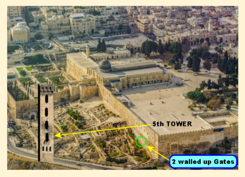
1. 5th TOWER- STABLE LEGION CAVALRY-3.png
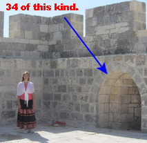
The walled up Gates used to lead the Cavalry's 300 Horse to their Stables. Roman Cavalry had to sleep in the same building as their horses. SO that second floor was Barracks for them.

Here is Josephus that is MOST INTERESTING.

QUOTE:
DID YOU NOTICE THAT ON THIS FACT SHEET FROM JOSEPHUS:
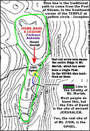
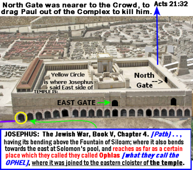
But if we go the other way westward, it began at the same place; and extended through a place called Bethso, to the gate of the Essenes: and after that it went southward: having its bending above the fountain Siloam; where it also bends again towards the east at Solomon’s pool, and reaches as far as a certain place which they called Ophlas
[what they called the OPHEL], where it was joined to the eastern cloister of the temple. The second wall took its beginning from that gate which they called Gennath, which belonged to the first wall. It only encompassed the northern quarter of the city, and reached as far as the tower Antonia. - Josephus The Jewish War Book V chapter 4
END QUOTE:


There is also a 5th TOWER that used to sit on the highway just before it bents west. I would have been 50% closer or more to the TEMPLE on the OPHEL. It was 75 feet tall, and from their they would have had the ideal view of the temple and courtyards.

The Biggest Mistake the Jewish Sanhedrin made when they came back after over a 1000 years in exile, is THINKING Mt. Moriah was a Single Peak. It is the Name of the whole Ridge, and the middle Peak is the real Mt. Zion.

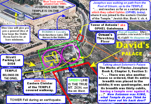
I am not sure if this site can handle a larger picture, but will try, so you can see a lot of what I discovered:

Z.Proof Temple belongs on OPHEL, DAVIDS Palace Next Door South.png

That Green Line, does NOT include the Court of the Gentiles, and Outer Wall, But it the Palaces that Solomon built had the TEMPLE almost bumped up against the Kings Palace. I hope these Pictures are Okay, let me know if I violated any rules. I am 74 years old, and feeling my age. I will post more Later.
 
Last edited:

VCO

Active Member
Mar 4, 2023
337
116
43
76
Lincoln, NE
Faith
Christian
Country
United States
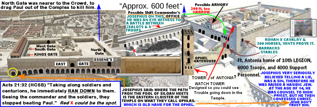
I improved on a stitched drawing, all the words are mine, except when I was quoting JOSEPHUS, and few other artist, an the main artist, Many thanks as without it, I could not have made this stitched drawing. READ it all, if you what to know the TRUTH.

1.  East Wall - Cloisters Added.png

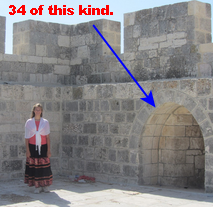
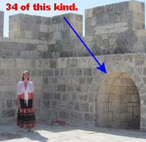
In that little photo, the lady is standing by a HUGE vent in the wall, venting the stink from 300 horses on the ground floor Stables. BUT there are 34 of those kind of VENTS along the east wall starting of that inserted photo in the upper left corner, and coming South to the corner and around almost to where that Possible ARMORY is. There were 300 horses assigned to every LEGION. Yes that FIFTH TOWER IS REAL, and there are ruins to prove it. AND it was 75 feet tall. See how it towers over the TEMPLE ROOF.

Vents to let the Stink Out - X.png
.
1678081391562.png
That BIG STINK requiring that much Ventilation, is the Roman X Cavalry with 300 Horses below on the Ground Floor. That is full PROOF that this Complex was all 100% ROMAN X LEGION's Fortress Antonia. I know what that BIG STINK smells like, I was raised on a dairy farm.
 

VCO

Active Member
Mar 4, 2023
337
116
43
76
Lincoln, NE
Faith
Christian
Country
United States
1678163257211.jpeg


The biggest mistake the Sanhedrin ever made was THINKING THE MT. MORIAH was a single Peak. It is the Name of the Entire Ridge. The Jews were in exile from 70 AD till 1212 AD. They came back to Jerusalem early in 1212 AD, Formed the Sanhedrin, and said that single peak of Mount Moriah is where the Temple is supposed to be, but they had 4 sites up there, and had a big argument about it, SO THE VOTED. And it NEVER WAS UP THERE. They forgot that Mt. Moriah was the name of the Entire Ridge. And that Mt. Zion the central Peak on was the actual LOCATION. YES, Mt. Zion, which they CHOSE be the VOTE too, was dead wrong too. Here is a map of Mt. Moriah and Mt. Zion, that it is where it is SUPPOSED TO BE:

1678159178126.png
 
Last edited:

VCO

Active Member
Mar 4, 2023
337
116
43
76
Lincoln, NE
Faith
Christian
Country
United States
1678171003050.png

Forgot, I already did a similar Post, however there is much more info on this post, so I will leave it. I have got an excuse for the forgetfulness, I am 74. Your day is coming.

How sure am I that the entire Complex up on the Temple Mount was Built for the ROMANS, specifically the Roman X Legion? That LEGION has almost 6000 Troops, and 4000 Support Staff. What most People do not know is King Herod considered his best friend, was no other than Mark Anthony. So what kind of proof did I find, that absolutely Proves it was Built for the Roman X Legion? Most here will NEVER recognize the Proof, because they are born and raised City Dwellers, and I am 100% sure that it was built for the Roman X Legion, because I was raised on a Dairy Farm. Here is the ULTIMATE PROOF, and unless you were raised on a Dairy Farm, with that kind of BIG STINK, you probably will not understand it.

This kind of VENTILATION System, means one thing, there were originally LOTS of animals on the Ground Floor, specifically 300 Horses.
1678172221470.png
Count them for yourself, and KNOW, that Caesar gave orders that Every Legion had to have 300 Horses, in the SAME BUILDING with the Cavalry; with no more than one floor between where the Cavalry sleep. Read History Books TOO. And who would want the TEMPLE of the LORD there, when that Summer Breeze would BLOW that BIG STINK, right into the TEMPLE. During the Summer months that smell will make most City Dweller SICK to their stomachs. To me, that FACT alone rules out the so-called TEMPLE MOUNT as being a place for the TEMPLE.
1678173067401.png
It is OBVIOUS, this place was deliberately build for the ROMAN X LEGION, with their 300 HORSES and appropriate Ventilation System. Right above the I in OBVIOUS, is the first one I see. So that STABLE ROOM probably runs from that point of number 1 Vent, clear down to that Southeast Corner, in the lighter grey color and across half ways. All of that had BIG VENTS built into the exterior walls along the east wall and south wall.


It is 100% Proof that the FORTRESS was built for the ROMAN ARMY, but almost NO City Dweller would even think of it. If you still Doubt me, then Plan a Vacation to western Nebraska, during the early part August. Just a couple miles east of Ogallala on I-80, is a huge Stockyard, on the south side of the Interstate Highway. Roll the windows down, and breath in that BIG STINK, until you are CONVINCED that no one would every want that SMELL to creep into the TEMPLE OF THE LORD above that BIG STINK, coming up those VENTS from 300 HORSES.

OBVIOUSLY THE TEMPLE WAS ON THE SOUTHWEST CORNER OF THE OPHEL.

1678294871319.png
 
Last edited:

VCO

Active Member
Mar 4, 2023
337
116
43
76
Lincoln, NE
Faith
Christian
Country
United States
TAKE A CLOSE LOOK AT THIS THAT I FOUND A COUPLE DAYS AGO!
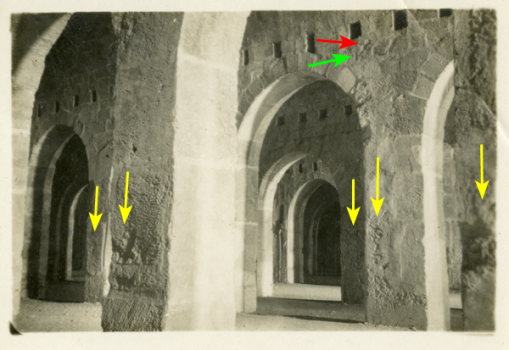
This is Ground Floor in the southeast corner of the Temple Mount!

1678434893542.png
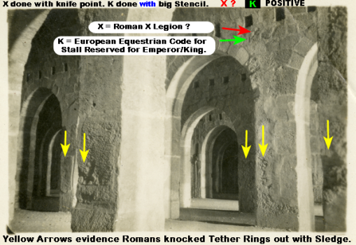
The red Arrow, is pointing to an X that was carved in there with a knife point.
AND the green Arrow is pointing to an K. Do you know what that means ? ? ?

It is part of an international symbolism that means X division reserves this stall for the EMPORER/KING, by putting the K there.
That Symbol was part of almost every Equestrian Units in Europe. I don't think the Jews bought in to that type of symbolism, but the ROMANS DID. That was called a Kaisar Symbol, and mean it was reserved for the Emporer/King. My mouth fell open when I read what it stood for.

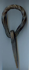
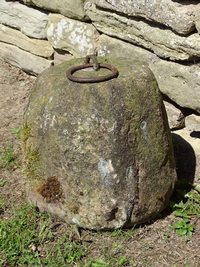
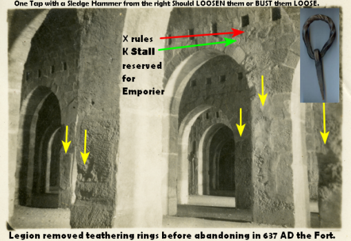
But there is more. Do you realize what those marks on the Pillars came from. The Tethering RINGS, that were REMOVED. THEY WERE NOT REMOVED BY JEWS, because after 70 AD they were expelled or exiled OUT OF THE COUNTRY, I can hear the Soldiers YELLING "GET OUT NOW, or DIE, YOUR CHOICE!" Now the JEWS did not REMOVE THESE TETHERING RINGS, they were Exiled to a foreign County. So the Roman Army had to remove them, in 637 AD, when they were Defeated by the Arabs. When they saw DEFEAT was inevitable, they sent a crew with sledge hammers, with the attitude, "You do not leave the Arabs anything of Value." Why the Placement of the Tethering Rings on the LEFT SIDE. Most Soldiers were Right handed, so you would place them on the left side, so that one blow with a sledgehammer would loosen the ring, or break it out as the picture Clearly shows. You had to have an extra Tethering Rings for Guests. I would guess about 324 Posts would be sufficient, for the 300 of the ROMAN X Cavalry, with 24 for GUESTS. YES, the ENTIRE TOP OF MT. MORIAH WAS FORTRESS ANTONIA.
1678437552352.png.1678437579358.png
 
Last edited:

VCO

Active Member
Mar 4, 2023
337
116
43
76
Lincoln, NE
Faith
Christian
Country
United States
Do you know what amazes me, is how stubbornly some People, especially Jews, can resist the Truth that the Places the TEMPLE was the OPHEL. Some People what to count the Stones as Evidence the Stones were part of the Stones part of the TEMPLE up TOP. When in reality ALL THE STONES FROM ALL OVER ANCIENT JERUSALEM WERE TORN UP AND DRUG UP HILL FOR A MASSIVE REBUILDING PROJECT, AELIA CAPITOLINA. JESUS SAID SO:

Matthew 24:2 (NCV)
2 Jesus asked, “Do you see all these buildings? I tell you the truth, not one stone will be left on another. Every stone will be thrown down to the ground.“

It means bare dirt, where the ROMANS MOVED THEM. To Where ? ? ? Up north where their next building project will start, as soon as their present Job of TEARING DOWN OF ANCIENT JERUSALEM gets finished. A fool would think they moved the Stones across the Valley, and then had to go get them to yet again to use them in Aelia Capitolina. They moved up north right beside their next building project.

1678666638878.png


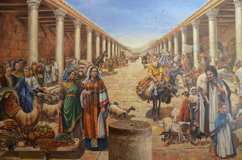
That may be what the artist in his minds eye saw, and he thought Aelies Capitolina looks like.
But what I want you to look at, is the stone work. ALL OF IT STONES USED TO BE IN AND AROUND THE CITY OF DAVID, INCLUDING THE WALLS, AND INCLUDING THE TEMPLE.

Then the idea that the ROMANS destroyed THOSE STONES is ridiculous, when they had a HUGE building project set to begin NEXT. An equally ridiculous IDEA IS that I saw on a video were they said: "we know Hadrian Stones were found at the Base of the western wall. So we know the Temple was behind that Wall." His work, was found ALL OVER Jerusalem, including up top of Mt. Moriah; PLUS all the stones from the City of David, were moved there too, for repair work, and new building projects. The Jews and Theologians that think that is valid evidence, did not think that one through.

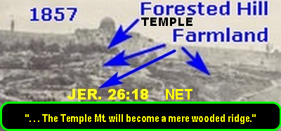
So you do not believe all of the City of David and the TEMPLE were TORN DOWN and moved North about a mile? Look at this, about 1860 photo:


1678669573997.png

Do you see anything left, walls, or buildings, or Temple, at all in Ancient Jerusalem (City of David). I see only two farm houses (modern), some out buildings, modern walls, and a modern storage bunker for potatoes in the lower left hand corner. And I a farm boy, and I SEE NOTHING ANCIENT.
 

VCO

Active Member
Mar 4, 2023
337
116
43
76
Lincoln, NE
Faith
Christian
Country
United States
1678908330767.png
That I have posted before, but here is the Reason:
With that X as verification that the Roman X Cavalry Unit was their, I can use other Picture that did not have LABEL on them, one picture same series of picture when all the rest we labeled Solomon's Stables. As such, and with good reason, I can rebuke the labeling it Solomon's, with room for 300 horses in that Horse Barn. That Photographer, never thought that one through, as the STINK FROM THE HORSES WOULD DRIVE WORSHIPPERS OUT, while insisting the Temple was on the highest hill, because THEY WOULD BE RUNNING FROM THAT SMELL. Buried in those WALLS above are 34 vents larger than a human being, and 3 times as wide, just to control it. It is baffling, when THERE ARE MANY THAT ARE STILL POINTING DIRECTLY WHERE THEY THINK THE TEMPLE IS, when every one of those were raised in the Big City, and therefore has NO IDEA HOW BAD IT SMELLS. My brother and I had to shovel out the Barn from out Dairy Cows, ever once in awhile. He had a week stomach, and 2 or 3 times during the Process he had to run outside and puke his guts out. AND we never had more that 24 Cows, but below that so-called Temple Mount, were 300 horses, at least. I had to laugh at everyone how he or she thinks it is okay to put a temple on the third floor above 300 horses. They are the ones I call CITY SLICKERS, they do not know much about raising animals on a farm. You do not want 34 big stink Vents pointing at GOD's TEMPLE, and neither does HE.
1679033663969.png
1679034796868.png

1678941838560.png
 
Last edited:

rockytopva

Well-Known Member
Staff member
Dec 31, 2010
5,588
2,756
113
Faith
Christian
Country
United States
Any theories as to the location of the Ark of the Covenant?
 

VCO

Active Member
Mar 4, 2023
337
116
43
76
Lincoln, NE
Faith
Christian
Country
United States
Any theories as to the location of the Ark of the Covenant?

I heard one archeologist several years ago, found what looked like it several ago, while he was peaking through a small crack in the wall at a sealed chamber. I have also heard the Jewish authorities know where it is, but they are not going to disturb it, until the Third Temple is ready. Another suspected site is in Ethiopia.

There were several Minora in temple, one is the Vatican maybe, one was in possession of the Knights Templar, and it may be hidden on Oak Island. Another one may be in the current site near the Dead Sea, that the archeologists are currently waiting to get permission to start a dig there.
 
Last edited:
  • Like
Reactions: rockytopva

VCO

Active Member
Mar 4, 2023
337
116
43
76
Lincoln, NE
Faith
Christian
Country
United States
I found that I had mis-spelled Emperor, and had one Yellow Arrow in the wrong place, so I edited it.

1680142591441.png
The reason I put a ? mark behind Roman X Legion is: The K seemed original detailing made by the Crew that Built this Large Stable, my Guess it was Built for the Legion, and one of the Roman X Cavalry scratched the X in there with his knife, but I cannot prove that.

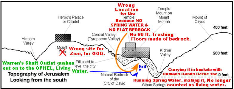
So what's wrong with the Temple being on the Highest Hill? PLENTY, every the red let's is Wrong and the real Mt. ZION is 600 south of the Al-Asqa Mosque.
1679809681976.png
 
Last edited: